
This month, Bucks County begins another set of repairs on Mood’s Covered Bridge in East Rockhill Township just outside Perkasie. It is the second covered bridge at that location, replacing one that lost in a 2004 fire.
The repairs are part of a $2.5 million project to update all seven covered bridges owned by Bucks County.

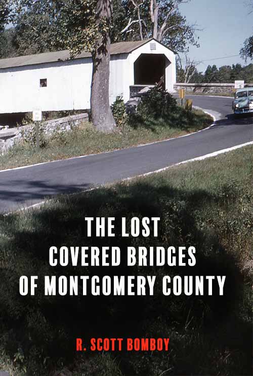
Mood’s Bridge in the 1950s. Photo by John C. Sinclair
The first Mood’s Covered Bridge over the East Branch of the Perkiomen Creek was also one of the last original covered bridges built by Bucks County. It opened in late 1874 after Perkasie’s founders petitioned the Bucks County Court of Quarter Sessions for a bridge at a fording location on the creek.
Joseph Hendricks and Joseph G. Moyer told the court in April 1873 the bridge was “much wanted” because the creek was frequently impassible because of “ice and high waters.” The only other bridge into Perkasie from the south was an open wooden bridge over Walnut Street at the end of the Bridgetown turnpike.
The court named three bridge inspectors from the public to view the location, who agreed with the local residents, and the court approved the bridge in November 1874 after it had been built by a local contractor and inspected by a jury.
It was originally called the Mood’s Ford bridge since it was near Samuel Mood’s farm. Mood’s obituary in 1902 said he was born in Tinicum Township but left to seek his fortune in the 1849 Gold Rush in California. Mood also worked on the Union Pacific Railroad before he returned to Bucks County to become a farmer, where he died as one of Perkasie’s wealthiest citizens. Mood was known for his colorful tales of life during the Gold Rush era.
Mood’s Bridge started experiencing condition issues by 1919 despite its relatively young age, compared with other Bucks County covered bridges. County engineer A. Oscar Martin inspected it on July 25, 1919. Martin said “Danger Signs” were posted at the bridge. Part of its roof was missing, the side planks were badly worn, and a beam was broken. (A year later, Bucks County paid Joseph G. Moyer $55 to replace the planks.)

Mood’s Bridge, July 1919
Still, a photo taken by Martin that day showed Mood’s Bridge was in much better shape in 1919 than in July 1937, when Bucknell professor Nelson Davis photographed it. Two years earlier, the state Department of Highways took over Mood’s Bridge during a period when the state demolished at least 24 covered bridges in Bucks County. Many of the Mood’s Bridge sideboards were missing and the bridge leaned to one side.

Mood’s Bridge in 1937. Photo by Nelson F. Davis
Somehow, Mood’s Bridge survived demolition. But as the Perkasie area grew after World War II, the bridge was in continual disrepair. By 1959, state officials had decided to demolish Mood’s Covered Bridge and also nearby Sheard’s Mill Covered Bridge. But public backlash over the possible demolition of the South Perkasie Covered Bridge in 1958 led State Highway chairman Park Martin to reconsider the two demolition projects. However, repairs weren’t made to the two aging bridges were slow to happen.
In March 1960, Bucks County Township Officials Association officials and the Bucks County Boroughs Association publicly pressed the state to repair the two bridges. Soon after, repair work began on both, with Mood’s Bridge getting a nearly complete overhaul completed in 1964.
However, the Mood’s Bridge rehabilitation project had problems when new wooden pegs holding the bridge’s truss together became loose and the bridge’s floor sagged. The bridge was closed again 1970 for a $155,000 renovation project. The county added steel beams and the bridge’s foundation and trusses were reinforced. The bridge’s closure for five years angered residents, since the closure blocked school buses from using Blooming Glen Road to get to Pennridge High School.
Mood’s Covered Bridge reopened in 1975 but was closed again after it sustained considerable damage in 1978 from a backhoe. It was struck by a falling tree in 1989 and closed again, causing more traffic problems. Mood’s Bridge also underwent more major repairs in 1996, when much of the bridge was replaced in a $277,000 project.

Mood’s Bridge, February 2004. Photo by Doris Taylor
In January 2004, a refuse truck one foot higher than the bridge’s clearance took out most of its overhead spans. PennDOT expected repairs to cost $50,000, with the refuse-hauling company paying the costs. Finally, on June 22, 2004, six men set fire to the closed bridge in the middle of the night. The men later pled guilty and agreed to pay restitution for about half of the costs of the new bridge.
The arson did not significantly damage the bridge’s deck and its steel support beams, and PennDOT at first said it would not build a replacement covered bridge; instead, it would use a temporary version with side rails at a $50,000 cost. East Rockhill Township then asked PennDOT to reconsider, and the Bucks County Commissioners agreed to assume the bridge’s ownership, with East Rockhill Township paying its insurance. PennDOT paid for most of the $850,000 project, with the new covered bridge placed in road service in February 2008. Community members also raised funds to support the project.
Today, it is unknown if any parts from the 1874 bridge exist in the new structure.


7 Comments
I think there may have been a house they used as a school on South Main/Branch Street before they built the one that still exists in South Perkasie. That map has the only reference to it I have seen, but there could be info on Newspapers.com, which has the Central News from 1881-1943.
Yes but the one in South Perkasie was located on the northeastern side of present day Walnut Street, near Coventry. The school on the 1891 map is located southwest of Walnut Street, near Wyckford Commons/Hillcrest Drive. What school was there?
There were two schools – one on current day South Main in South Perkasie and one on Chestnut Street.
The school on the 1891 map located on Branch Road across from the Samuel Slotter tract is the physical location of present day 509 W. Chestnut St. in Perkasie Borough?
509 W Chestnut Street
It is the white building on Chestnut Street just above Fifth Street – 509 W Chestnut Street. It is mentioned in the old newspapers. It was later used as a cigar factory and a boarding house.
Unrelated to this specific post, but what school is noted as “Old School” in the lower left corner of the 1891 map from your Perkasie Facebook page? No local history accounts ever mention this school. And where exactly would that location be today?
https://m.facebook.com/groups/171800043350443?view=permalink&id=171815310015583&sfnsn=mo