
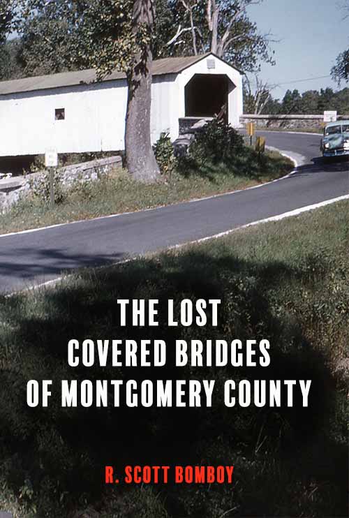
Bucks County is well-known for its history and an important part of that story is its collection of wooden covered bridges. Currently, 12 of the structures remain in the county, with 10 of the original bridges listed on the National Register of Historic Places.
What’s forgotten today is the county’s legacy as one of the early centers of covered bridge building in America. Since 1806, Bucks County has had at least 51 wooden covered bridges in place at various times, according to records at the Bucks County Historical Society in Doylestown, Pa. The bridges played an important 19th-century role in connecting formerly disconnected communities, usually in conjunction with mills that produced goods and services that were vital to the region’s pre-industrial economy.

Loux Bridge as photographed by the Historic American Engineering Record
For example, one bridge/mill combination on the Delaware River Division canal near Kintnersville produced hydraulic cement in the 1830s used to build canal locks. Down river, other bridge/mill combinations in Uhlerstown and Pipersville allowed farmers to refine their own grain for human and livestock consumption, and to saw lumber. A nearby covered bridge sat on River Road in Tinicum, allowing goods and services to move up and down the Delaware River roads in conjunction with the canal, and into country villages that consumed products and had goods to sell.

Uhlerstown Bridge photographed for a 2005 HAER Survey. Mills and canals were important parts of the covered bridge network
Covered bridges connected the mills and farms to a growing 19th-century road and canal network that formed the regional economy’s backbone, not just near the Delaware River but also at inland villages on the Neshaminy and Perkiomen Creeks. Large covered bridges in New Britain, Line Lexington, and Warwick opened up arterial roads such as the Old York Road, County Line Road, and the road that connected Doylestown (the Bucks County seat) to Norristown (the Montgomery County seat) to commercial traffic and pedestrian travel.
All Posts In The Series
- Discovering Bucks County’s Covered Bridges (Part 1)
- The Delaware River Covered Bridge Network (Part 2)
- How Bucks County lost and then saved its covered bridges (Part 3)
- Modern Covered Bridge Preservation Efforts in Bucks County (Part 4)
In parallel, a different covered bridge network spanned the Delaware River during the 19th century, allowing commerce between Pennsylvania and New Jersey. Before 1806, ferries were used exclusively to take goods, people, and livestock over the Delaware River in Bucks County.[1] By 1876, a network of 11 large covered wooden bridges extended over the 36-mile distance on the river between Riegelsville (at the north end of Bucks County) and the Trenton-Morrisville Bridge (the regional business hub).

The bridge at Taylorsville or McKonkey’s Ferry just before its 1903 destruction. Today, the area is called Washington’s Crossing. Image: Theodore Burr Covered Bridge Society.
The high-water mark for the Bucks County covered bridge network came in early October 1903, when at least 48 covered bridges were in active service in the county. By 1947, that number dropped to 15 covered bridges, as Mother Nature ended the wooden-bridge network over the Delaware River, and modern highway demands saw county and state officials demolish at least inland 21 covered bridges between 1921 and 1940.[2]

Bucks County once had at least 51 covered bridges. The red markers indicate the 12 covered bridges that still exist. The black markers show where bridges once stood.
However, local movements centered on preservation influenced government transportation policy in the late 1950s and led to an end of the tactic of demolition as the preferred method of dealing with wooden bridges in need of repair. Publicity over Bucks County’s condemnation of the South Perkasie Covered Bridge in 1957 and the bridge’s subsequent removal in 1958 saw a coalition of local groups, including some government agencies, petition the state to make covered bridge preservation its official policy, which it did in 1959.

The 1958 South Perkasie Bridge move in August 1958 was a turning point in regional covered bridge preservation. Image: Theodore Burr Covered Bridge Society.
Bucks County adopted a similar stance to the 13 covered bridges that remained in the county, seven of which it owned. County and state officials worked together on bridge maintenance after 1959 and dealt with controversies when three bridges were later destroyed by arsonists. Two of the three bridges were rebuilt with the help of private-sector funds and workers.[3] And in 1980, Bucks County’s bridges were placed on the National Register of Historic Places as part of a survey of the Delaware River watershed.[4]
In the following series, I will discuss three different eras: the Delaware River era (1806-1945), the Inland Bridge era (1820-1939), and the Covered Bridge Preservation era (1958-2018). To complete this project, I received full access from the Bucks County Historical Society to its archives, including bridge inspection reports from the noted county engineer A. Oscar Martin, and additional help from the Bucks County Covered Bridge Society and the Theodore Burr Covered Bridge Society. Without that support, this project would not have been feasible.
I’ll try to post part one this weekend – and don’t forget the Perkasie Historical Society will have special displays on August 18 and August 19 to commemorate the 60th anniversary of their covered bridge move. As you’ll learn, if any one group deserves extra credit for saving our county’s covered bridges, it is the Perkasie Historical Society, and the work of Andy Schuler and Claude Bowen back in the 1950s to set an example for others to follow.
Link to Part 2: The Delaware River Covered Bridge Network (1814-1945)

The Spring Garden Mill bridge sat in the current Tyler State Park, and a couple had hoped to convert it into a house. But Hurricane Diane had other plans in 1955. Image: Theodore Burr Covered Bridge Society
Footnotes
[1] B. F. Fackenthal, Jr., “Improving Navigation on the Delaware River with Some Account of Its Ferries, Bridges, Canals, and Floods.,” A Collection of Papers Read before the Bucks County Historical Society, Vol. VI, 1932. Fackenthal’s 128-page study of the pre-industrial Bucks County ferry system includes a review of the privately owned Delaware River bridges and the storms that often destroyed them.
[2] David W. Wright, William S. Caswell, and Dan Brock, World Guide to Covered Bridges (Hillsboro, N.H.: National Society for the Preservation of Covered Bridges, 2009). This national list of covered bridges began in the 1950s as an effort to catalog current and past structures. However, archival records from the Bucks County Historical Society were used for this study, since official records stored at the BCHS showed inconsistencies with the World Guide data.
[3] A volunteer group funded the building of a new Twining Ford or Schofield Covered Bridge in Newtown, Pa. between 1991 and 1997, while the state rebuilt Mood’s Bridge in Perkasie, Pa., between 2004 and 2008. Haupt’s Mill Bridge wasn’t rebuilt after a 1985 arson when local residents couldn’t agree on the need for a replacement bridge, and government officials didn’t budget for a new bridge for a road that was mostly out of service.
[4] United States, Department of Interior, Heritage Conservation and Recreation Service, National Register of Historic Places, Inventory and Nomination Form, Covered Bridges of the Delaware River Watershed (Washington, DC: National Park Service, 1980).


Trackbacks and Pingbacks
[…] Link To Part 1 In The Series: Discovering Bucks County’s Covered Bridges […]