
You’ve seen them in gift shops, museum book stores and maybe you have one of them in your house: an aerial view of your hometown a generation before airplanes existed. The story behind these maps is fascinating, and the work of three researchers reveals secrets left behind nearly 100 years ago.

A handful of artists walked the American countryside drawing nearly 1,800 maps over a three-generation period that showed life in small towns and big cities from the Civil War until the early 1920s. Some of the maps are staggering in detail. Thaddeus M. Fowler, the most prolific artist of panoramic or birds’ eye view maps, spent four years drawing a highly detailed map of Allentown, Pa., right before his death in 1922. Fowler died at the age of 80 from complications caused by a broken leg; he was hurt while walking and drawing around Middletown, N.Y., in his 54th year as a map artist.

Thaddeus Mortimer Fowler. Source: Library of Congress
We know a lot about Fowler and the other map makers thanks to three people. Professor John Reps at Cornell University published an exhaustive study of panoramic maps in 1984. A decade earlier, the Library of Congress published a directory and explanation of birds’ eye maps compiled by John Herbert. Herbert had been in touch with map collector and amateur historian James R. Warren Sr., who spent most of his adult life collecting panoramic maps and had become friends with Fowler’s family in Morrisville, Pa. Warren then donated his map collection to the Library of Congress in conjunction with the Fowler family.
Fowler spent much of his career drawing maps in Pennsylvania. After he was wounded at the second Battle of Bull Run in the Civil War, Fowler was discharged from the Union army and went to work for a relative in Wisconsin who was a photographer. Fowler then became a helper for Albert Ruger, an early panoramic map drawer, where he learned the intense process of drawing birds’ eye maps.
Part of the process was drumming up business for locals who would buy printed maps. Fowler and other agents assisted master map makers would walk the streets sketching quadrants, getting people interested in buying maps, and working with lithographers who etched the final drawings into a limestone slab that printed highly detailed prints.
When Fowler started his own business, he had steady, lucrative work for a long time. In 1894, his busiest year, he not only executed maps of four neighboring towns outside of Philadelphia – Perkasie, Sellersville, Souderton and Telford – Fowler did more than 21 other maps. By Reps’ estimate, each map took about two weeks to execute before it went to the lithographer. (In Fowler’s case, he partnered with James R. Moyer to help compile, market, and print the maps.)
Fowler’s process started with evaluating which part of Pennsylvania he would map for the year. In 1885, Fowler had settled at Morristown, Pa., near Trenton, an area that contained easy access to Pennsylvania and New Jersey. Over the next 25 years, Fowler produced more than 200 maps of the Keystone State.

Fowler’s 1893 map of Morrisville.
For 1894, Fowler and Moyer concentrated on eastern and central Pennsylvania for the map-making season. A look at how he produced the Perkasie and Telford maps shows how the maps were produced and marketed.
“Fowler gained commissions for city plans by interesting citizens and civic groups in the idea of a panoramic map of their community. After one town had agreed to having a map made, he would seek to involve neighboring communities,” Herbert said. Fowler and other artists appealed to civic pride and would feature business and houses in special inserts for an extra fee. For example, once Perkasie had a map, neighboring Sellersville would obviously need its own map.
A look at the Fowler map for Perkasie shows the basic technique behind map making. Fowler would need to show a view that showcased a town center – where the potential map buyers lived. Usually, a town’s most important feature was placed in the foreground. Here, he picked the Perkasie Park camp meeting ground, the town’s biggest tourist attraction.

Fowler would need find a viewpoint that allowed him to showcase the town’s street grid. The street grid lines there drawn at slight angles that led to them converging in the far distance at vanishing points. In the picture below, the heavy black lines show how this technique worked.

Using this viewpoint technique, Fowler could make more buildings bigger in the foreground and the center – increasing the chances those building owners would buy his map. In other cases, buildings owned by potential customers or important to the town received callout names and numbers. Fowler also tossed in the neighboring village of Benjamin in the right background.
For the Perkasie map, it’s noted that Fowler personally drew the map. The standard process was for the map maker to start with a large basic sketch with a grid. He would then walk through the entire town with a sketch pad, doing basic drawings of each block or area with field notes that indicated compass directions and its relationship to its next block. Fowler would then draw simple figures on his original large grid sketch to compile a conceptual drawing to show to his potential customers in Perkasie.

Fowler’s Perkasie town center in 1894.
Once enough people agreed to “subscribe” to the map, Fowler drew a detailed map. As Reps noted, Fowler used a sparse mechanical drawing style to show buildings and features. He noted the buildings in most of Fowler’s 400-plus drawings look similar. To Fowler, it was important to get the buildings in the right locations in town to make his customers satisfied. Accuracy was more critical that aesthetics. Once the detailed drawing was done, it was sent to the lithographer. The entire detailed drawing had to be redrawn in crayon on a stone plate and etched at the lithographer. A skilled lithographer also would have directions from Fowler to add features on the stone plate. A limited number of prints were made and then delivered by Fowler or Moyer to the subscribers.
In the Perkasie map, it’s clear that Fowler concentrated on the town center. Several buildings, including churches, are a little bigger scale. Also, by putting the Perkasie Park camp meeting in the foreground, Fowler eliminated part of neighboring Sellersville from his map.
Perkasie does appear in Fowler’s Sellersville map as the vanishing point location in the upper left corner. There are some Perkasie details in the Sellersville map, including a rough sketch of the Perkasie Park camp meeting and neighboring Benjamin. Fowler probably executed his Perkasie map first, and then proceeded west to do separate maps of Sellersville, Telford, and Souderton.

His map of Telford, Pa. shows another popular money-making technique: the inclusion of a vignette in the drawing. The map’s perspective doesn’t allow for a detailed look at the County Line Hotel, which paid Fowler a premium to add it as a separate view on the map. The quality of the lithography shows architectural details even today in that drawing.

Fowler’s Souderton map is from yet another perspective, with most of the town in the foreground and no labeled depictions of other towns in the distance. But he does show several trains on the North Pennsylvania Railroad heading to and from Souderton.

What value do these maps have today? The original lithographs are highly prized by collectors. For genealogists, the detailed Fowler maps fill in valuable gaps of information, especially when combined with census data and tax records. And for historians, the maps show how communities functioned in the Victorian era, when combined with atlas maps.
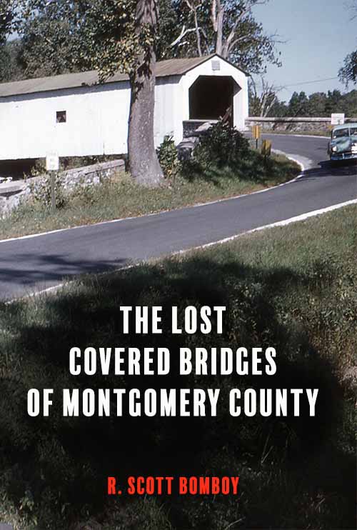
In the case of a town like Perkasie, its Fowler map shows how the town was oriented around its cigar-making businesses, the railroad, its newly built churches, and a new housing boom. In 2018, many of those buildings have vanished due to several fires and a 1960s urban renewal plan that demolished Perkasie’s original town center. The Fowler maps are highly detailed records of a time gone by that still has value today.
To see the full online collection of Fowler maps at the Library of Congress, go to: https://www.loc.gov/search/?fa=contributor:fowler,+t.+m.+%28thaddeus+mortimer%29&q=fowler+maps


One Comment
you call his home morristown, pa, but it is morrisville.